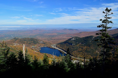
Trip Summary: via the Kinsman Ridge Trail
Elevation: 4,080 ftTotal Distance: 4.5 miles
Estimated Time: 5 hours (round trip)
Difficulty: Moderate, but some places are Difficult
Views: Excellent; 360 degrees
From I-93 take exit 34B for the Cannon Mountain Aerial Tramway Parking. At the back left end of the parking lot there is a row of port-o-potties. Follow the dirt road past them and around to the right to the parking lot for the Kinsman Ridge Trailhead. The trail begins at the far left end of the parking lot.
The trail doesn't keep you waiting but starts right in with an incline and keeps going straight up. It is well marked with blue rectangles. You are often climbing over boulders and roots and some rock steps. There are some steep sandy sections that look like water runoff "river beds" which would probably be quite messy if the weather has been rainy. And there are occasional sections where you are climbing up slanted rock faces, which will also be slick when wet.
This trail runs parallel with the Tramway, but it is deep enough in the forest that you rarely notice. Along the way there will be clearings with nice views to the north overlooking Echo Lake. Take these photos now because the lake will be hidden from view from the peak.
After about 1.5 miles the trail will turn to the left and flatten out. There will be a fork in the trail (though it's easy to miss). Stay to the left to go out to a beautiful overlook. This is just above where the Old Man in the Mountain used to be.
Then retrace your steps and take the righthand fork to continue toward the summit. This section is fairly easy and not so steep at all. You will then come to an intersection with the Rim Trail Loop which encircles the summit. This is basically flat and very easy because all the people coming up the Tramway use it. You can go to the right toward the summit lodge where you can use the bathroom, buy food and drinks, and refill your water. Or go to the left toward the Overlook Tower at the peak with more viewpoints toward the east and south along the way.
 |
| views to the east and south over the Franconia Ridge (click to enlarge) |
 |
| views to the north (click to enlarge) |
Then retrace your steps to descend, and be careful on the steep slippery sections.
Official Trail Map: (click to enlarge)
 |  | |
| via Kinsman Ridge Trail | via Hi-Cannon Trail |


No comments:
Post a Comment