Trip Summary
Galehead elevation: 4,024 ft
Difficulty: Easy
Views: None at the summit; Ok from nearby overlook
Garfield elevation: 4,500 ft
Difficulty: Garfield Trail is Easy; Garfield Ridge Trail has one Difficult section
Views: Excellent; 360 degrees
Total distance: 14 miles
Estimated time: 8-10 hours
Note: This loop hike can be done in either direction, but I would recommend doing Galehead first and finishing on Garfield with its incredible views.
| To park at the Garfield Trail trailhead, just before you cross the bridge over the Gale River, there is a right turn onto a dirt road marked only by a White Mountains trail parking sign. Follow this road for 1.2 miles over 3 wood bridges. The road will turn to the left, and then immediately on the right is a small roadside parking lot. |  |
 |
To park at the Gale River parking lot, from Rt. 3 North turn right on the unmarked dirt road opposite Trudeau Rd and the Bethlehem Visitors Center sign. After 0.6 miles stay to the left at the fork, then after another 0.7 miles turn right. You will find the parking lot in 0.3 miles on the left. |
At the east end of the parking lot is the trailhead for the Gale River Trail. It is an easy straight shot with a very gradual incline for quite a ways. The trail is marked by blue rectangles, but not always well marked. You cross many little tributaries, sometimes on manmade bridges.
 |  |
 |
 |
The last half mile or so when you're climbing the side of the ridge, it gets steep and is basically a rock staircase. At the top you'll intersect with the Garfield Ridge Trail and go to the left toward the Galehead Hut.
 |
 |
This section is less steep, but still a rocky scramble. After 0.6 miles you will intersect with Twinway and Frost Trail. Go to the right up to Galehead Hut. This is a good place for a rest, buying a snack, refilling your water, and using a proper bathroom. Since this is part of the Appalachian Trail and the Pemi Loop, it can be busy at times.
 |
 |
 |
 |
 |
| View from the Galehead Hut |
The Frost Trail continues out the other side of the Hut from where you entered. From here it is only a short half mile to the peak. In only 100 yards the Twin Brook Trail will continue straight, but go right to stay on the Frost Trail.
 |
 |
| Trailhead from the Galehead Hut | Intersection with the Twin Brook Trail |

Go back the way you came and now take the time to check out the overlook across to the Twin Ridge.
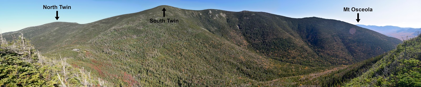 |
| Views to the east and south (click to enlarge) |
Mount Garfield
The Garfield Ridge Trail is marked by white rectangles. It starts off with some steep rocky sections up to a bare rock viewpoint that looks back to Galehead and South Twin. The next section has a few rock slides but is mostly flat like a typical ridge trail. According to the topographical map you go over a few small peaks, but you don't even notice. The Franconia Brook Trail will come in from the left. This goes into the Pemi Wilderness and the 13 Falls Tentsite. Continue straight on the Garfield Ridge Trail.
 |
 |
| Bald rock with a viewpoint | Franconia Brook Tr. intersection |
 |
| Looking back down the steep waterfall |
 |
| Trail to the summit |
 |
| Views to the North and Northwest (click to enlarge) |
 |
| Views to the East (click to enlarge) |
 |
| Views to the South and Southwest (click to enlarge) |
To descend, go back down the last 0.2 mi you came up. Then continue straight down the Garfield Trail for 4.8 miles. The trail is marked by blue rectangles. It's a fairly gentle descent with a few switchbacks down the side of the mountain. It can get fairly soggy at places with the runoff water. After the switchbacks the trail widens and straightens out to follow an old fire road for quite a ways. After crossing a foot bridge, the trail narrows back to a footpath out to the parking lot. Hopefully you can catch a lift from a fellow hiker back to your car.
Official Trail Map: (click to enlarge)

No comments:
Post a Comment